
 |
| Photo by Marie Martin |
The Middle or Lesser Himalayas
The mountain range which runs parallel between the Shiwaliks in the south and the Great Himalaya in the north is classified as the Middle Himalaya, sometimes also called Himachal or Lower Himalaya. It has an intricate system of ranges that are 60-80 km wide having elevations varying from 3,500 to 4,500 mt above sea level. Many peaks are more than 5,050 mt above sea level and are covered with snow throughout the year. Pir Panjal, the Dhaola Dhar, the Mussoorie Range, the Nag Tiba, and Mahabharata Lekh are some of the important ranges of the Middle Himalayas.
The Pir Panjal, the southernmost range of the Middle Himalayas, in Kashmir is the longest and the most important range. It extends from the Jhelum river to the upper Beas river for 300-400 km and is separated from the Zaskar Range by the Valley of Kashmir. Mostly the creation of volcanic rocks the Pir Panjal Range rises to 5000 mt and more in elevation. Some of the most important and known passes of Pir Panjal are the Pir Panjal Pass (3,480 m), the Bidil pass (4,270 m), Golabghar Pass (3,812 m), and Banihal Pass (2,835 m). The Banihal pass is used by Jammu Srinagar Highway. The Kishanganga, the Jhelum, and the Chenab cut through this Range, passing through Dalhousie, Dharmshala, and Shimla.
Between the Pir Panjal and the Zaskar range of the Main Himalayas, lies the famous valley of Kashmir running over a distance of about 135 km in southeast to northwest direction. This valley is about 40 km broad and extends in an area of 4921 sq km with an average elevation of 1,585 mt. above mean sea level. Geologists and geographers have divergent views regarding the origin of this valley. According to Wadia, the Valley of Kashmir is the synclinal basin enclosed between the Pir Panjal to the south and an offshoot of the center axial range to the north while de Terra feels that it is a recently depressed intermont basin pointing to the evidence of faulting on the Himalayan flank. However, it is generally believed that this basin was occupied by a lake in the Pleistocene age. This was filled with sediment and uplifted to form the Kashmir Valley. The synclinal basin of the valley is floored by varieties of the alluvial deposit.
Further east, the Middle Himalayas are marked by the Mussoorie and the Nag Tiba Ranges. The Mussoorie Range has an average elevation of 2,000- 2,600 m and runs over a distance of 120 km from Mussoorie to Lansdowne. Mussoorie, Nainital, Chakrata, and Ranikhet are some of the important hill stations situated between 1,500 to 2,000 meters above sea level.
On the whole, The Middle Himalayan Ranges are less hostile and more friendly to human contact. Majority of Himalayan resorts like Shimla, Mussoorie, Ranikhet, Nainital, Almora, Darjeeling, etc are located here.
The Great Himalaya
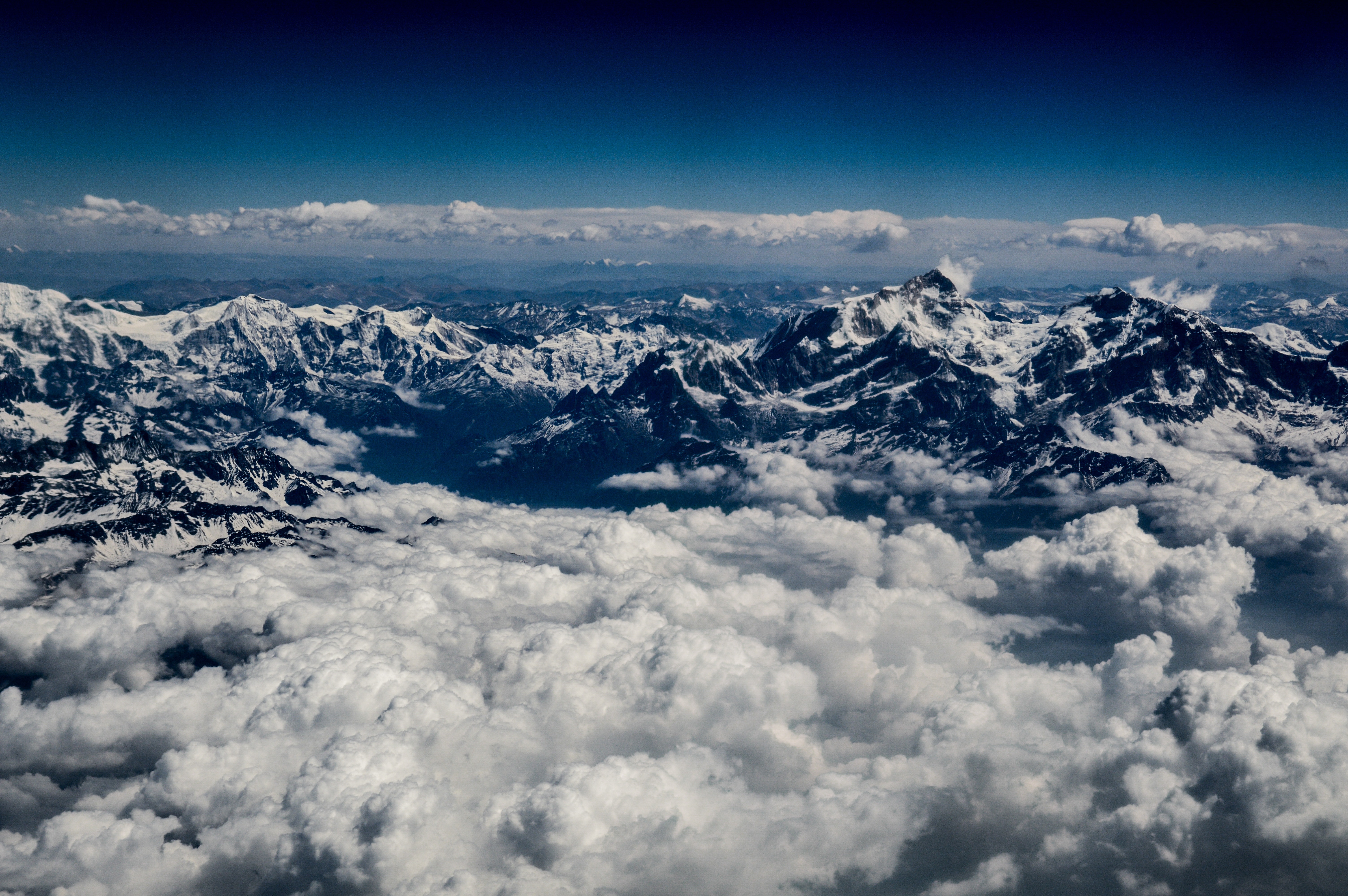
The Great Himalaya, also known as Inner Himalaya, Central Himalaya, or Himadri, is the loftiest and the most continuous mountain range in the world. This is the northernmost or the innermost of all Himalayan ranges. It has an average elevation of 6,100 mt above sea level and an average width of about 25 km. The Great Himalaya is formed mainly of the central crystallines (granites and gneisses) overlain by metamorphosed sediments. Like in all Himalayan ranges, folds are asymmetrical with a steep south slope and gentle north slope. This mountain arc, convex to the south, terminates abruptly in the Nanga Parbat in the northwest and in the Namcha Barva in the northeast.
This mountain range comprises some of the tallest peaks in the world, most of which remain under perpetual snow. Among the several peaks which are above 8000 mt in altitude, Mount Everest is the highest, which rises to the elevation of 8,850 mt. Nepalese call it Sagarmatha which means 'The Goddess of the Sky' while in Tibet it is known as Chomlungma. Located at 27 degrees 59' 16" N latitude and 86 degrees 55' 46" E longitude this peak was first by George Everest, the then Surveyor General of India in 1841, and in 1852 it was established as the highest peak of the world by the Great Trigonometrical Survey of India. In 1865 it was named Mount Everest as a tribute to George Everest. However Chinese want it to be named Qomolangma, meaning the "Mother of The World". China claims that this peak was mapped by Qing dynasty officials in 1717. The other important peaks in descending order of altitude are Kanchenjunga, Lhotse, Makalu, Dhaulagiri, and Manaslu. Cho Oyu, Nanga Parbat, Annapurna, Gosainthan or Shisha Pangma. The number of known peaks elevated over 7,000 mt exceeds forty. Some of the important peaks between 7,100 to 8,000 mt elevation are Nanda Devi, Kamet, Namcha Barwa, Gurla Mandhata, Badrinath, Trishul, etc.
This range is so formidable that it can not be easily crossed even through the passes because they are generally higher than 4,570 mt above sea level and are snowbound for most of the year. The Burzil Pass and Zoji La in Jammu and Kashmir, the Bara Lacha and the Shipki La in Himachal Pradesh, the Thaga La, the Niti Pass and the Lipu Lekh in Uttarakhand and the Nathu La and Jelep La in Sikkim are important passes through the Great Himalaya.
Here we completed the classification of the Himalayan Ranges. In the next post, we will discuss the remaining two divisions of the Himalayas- the Trans Himalayas and the Eastern Hills or the Purvanchal.